Ashridge Ace of Herts
We welcome you to our biggest event of the year, the Ace of Herts, a National event which is a round of the South East Orienteering League. It’s not just for experts, there are courses suitable for everybody and help for newcomers.
You should not come if you have symptoms of COVID-19, are required to isolate, are awaiting the results of a non-routine COVID-19 test or are serving a quarantine period after travel. You’ll get a full refund.
24 February: These are now final details. You may print them using the blue Print this page button at the bottom of the page. Any further updates will be highlighted in red here.
| Location | Parking at Tring Station HP23 5QR, OS grid SP951122, What3words below.commenced.eyelash | |||||||||||||||||||||||||||||||||||||||||||||||||||||||||||||||||
| Terrain | Ashridge East is a fine area of gently undulating deciduous woodland with a scarp slope to the south with areas of contour and vegetation detail. The latter is only visited by the longer courses.
The going is generally very fast with some limited areas of denser woodland. In the southeastern part of the eastern section in particular, there are many more brambles, so courses have been planned to minimise use of this area. The major and large paths can be muddy, making straight routes through the forest more attractive. The National Trust have asked that if you do run along paths, you follow the main line even if it is wet or muddy; running round the edges damages the vegetation much more. Notices asking the public to stay on the paths because of deer management activity can be ignored and there will no such activity on the day of the event. The area is much used by walkers (many with dogs and/or buggies) and horse riders. Please be considerate to them to help ensure our continued access to this area. We would like to thank the National Trust, and Ashridge Estate in particular, for access to this excellent forest. Thanks also to Ashridge House for allowing us to turn buses round. |
|||||||||||||||||||||||||||||||||||||||||||||||||||||||||||||||||
| Parking | Parking at Tring Station HP23 5QR. Note this is not in the town of Tring itself.
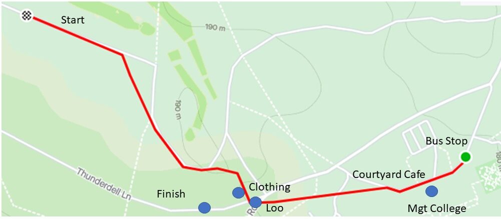
Use the footbridge to cross the railway line (not the bridge on the road you came in on, which has a very narrow footway). Shuttle buses will then take you to the start and from the finish. Wear a face covering on buses, unless you are exempt. Please do not wear muddy or spiked shoes on the bus. There is a clothing dump near the finish where you can leave warm clothing, clean shoes etc. You may be waiting ~15 minutes for a bus.
There are a few closer parking spaces for those who are shielding, please contact the organiser. Please do not attempt to use the “usual” National Trust car parks. They have explicitly requested that we do not and we do not wish to jeopardise our relationship with the National Trust. There will be few facilities in the forest – a clothing dump and one loo, principally for volunteers. Please do not rely on it! |
|||||||||||||||||||||||||||||||||||||||||||||||||||||||||||||||||
| Public Transport | Tring station is on the main line between London Euston and Milton Keynes with hourly trains on a Sunday. | |||||||||||||||||||||||||||||||||||||||||||||||||||||||||||||||||
| Courses |
The age classes are those recommended for the South East League. You may run any course you wish, but please take note of the course closure time if you are running a longer course than usual. |
|||||||||||||||||||||||||||||||||||||||||||||||||||||||||||||||||
| Course Notes | Black course has 37 controls so a more recent dibber will be needed. We will issue one with enough capacity at no cost if you ask at Download before you get on the bus.
The going is generally very fast with some limited areas of denser woodland. In the south-eastern part of the eastern section in particular, there are brambles of varying height, obscuring many previously runnable areas. Courses have been planned to maximise use of the runnable areas. Longer courses (Blue-Black) include a two-minute timed-out crossing of the main North-South B4506 road with fast-moving traffic. Courses from Very Short Green upwards include unmanned crossing of minor roads. The roads themselves may be crossed but not run along. The area is much used by walkers (many with dogs and/or buggies) and horse riders. Please be considerate to them to help ensure our continued access to this area. |
|||||||||||||||||||||||||||||||||||||||||||||||||||||||||||||||||
| Maps and control descriptions | Maps are on waterproof paper, scale 1:10,000 with a 5 m contour interval for all courses. Black to Blue maps are A3, Short Blue to White A4.
Loose control descriptions, pre-printed on waterproof paper, will be in the start lanes. They will also be printed on maps. |
|||||||||||||||||||||||||||||||||||||||||||||||||||||||||||||||||
| String course | Sorry, we are unable to put on a string course | |||||||||||||||||||||||||||||||||||||||||||||||||||||||||||||||||
| Starts | You may choose a start time between 10.00-12.30. Please make every effort to get there for your start time although late starts will be available. Courses close at 14.30.
White and yellow maps available at pre-start. Allow plenty of time to get to the start. Buses will run about every 15 minutes and take 15 minutes to get to the drop-off point. Bus stop at Ashridge Management College is 400m from clothing dump, further 400m to pre-start. Finish is 50m from clothing dump. Please follow signs and tapes to start. Keep Off Grass in front of college.
|
|||||||||||||||||||||||||||||||||||||||||||||||||||||||||||||||||
| Entry & Fees | There will be no entry in person on the day. Entries now open at SI Entries, while maps available.
SIAC (contactless timing chip) dibber hire £2. Charge for lost dibbers £65. You can enter online up to 1100 on the day, but if you need SIAC hire please enter by Friday 25th 23:59. |
|||||||||||||||||||||||||||||||||||||||||||||||||||||||||||||||||
| Punching | SIAC will be enabled. You must punch the start and finish controls. | |||||||||||||||||||||||||||||||||||||||||||||||||||||||||||||||||
| Facilities | At Tring Station: parking, portable loos, download, enquiries, SIAC pickup
In the forest:
Very near the bus stop and the finish is the Ashridge Management College Courtyard Cafe serving hot and cold drinks, cakes etc. We are very welcome to use it. Bring a means of payment in your coat? Don’t miss the last bus back shortly after 14:30! |
|||||||||||||||||||||||||||||||||||||||||||||||||||||||||||||||||
| Assembly | At Tring Station | |||||||||||||||||||||||||||||||||||||||||||||||||||||||||||||||||
| Results | Live results will be posted every few minutes to https:www.herts-orienteering.club. Full results will be published on the same page and on Routegadget as soon as possible after the event. We aim to put provisional results up that evening. |
|||||||||||||||||||||||||||||||||||||||||||||||||||||||||||||||||
| Event cancellation | Extreme weather conditions could result in late cancellation of the event. Every effort will be made to inform competitors as soon as is possible after a decision has been made. If cancellation is needed a message will be posted on the www.herts-orienteering.club website and an email sent to all those entered.
Please check before travelling. |
|||||||||||||||||||||||||||||||||||||||||||||||||||||||||||||||||
| Dogs | Dogs are permitted in the assembly area in cars or on leashes (but it’s tarmac). They are not allowed to accompany runners on the buses or on courses. | |||||||||||||||||||||||||||||||||||||||||||||||||||||||||||||||||
| Safety | Orienteering is an adventure sport. You take part at your own risk and are responsible for your own safety. A full risk assessment has been carried out.
Climbing of fences is strictly forbidden. You are advised to carry a whistle. In the event of extreme weather on the day, cagoules may be compulsory and you will be informed before you get on the bus. Come prepared. Large numbers of deer live in Ashridge; please allow them to move away from you without chasing and panicking them. If ever a deer does not move away from you then it is injured and should not be approached. Ponds and marshy areas may be deeper and muddier than you think. Paths can also be muddy. The area is popular with cyclists, dog walkers and horse riders. Please show them due consideration. First Aid will be available at the finish. The nearest hospital is the Luton and Dunstable Hospital Trust, Lewsey Road, Luton LU4 0DZ, 9 miles from the event. You must go to Download (at the station) even if you don’t finish your course. We need to confirm you’re back safely. |
|||||||||||||||||||||||||||||||||||||||||||||||||||||||||||||||||
| Officials |
|
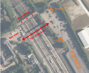 Use the main car park to the east side of the railway line. There are 500+ spaces. Cost per car is £6 all day on a Sunday, payable contactlessly, enforced by ANPR. West Midland Trains operates a No Smoking policy, including car park areas.