Hatfield South Urban Race
Welcome to this urban orienteering event in Hatfield.
Details now final. You may print them using the blue Print this page button at the bottom of the page. Any late changes will be noted here:
15 Aug details now final
Key things you need to know
- Parking is free of charge and is at the university multi-storey car park off Roehyde Way, Hatfield AL10 9EJ (signed: The Forum)
- Walk or bus ride from Hatfield station
- Event Centre has Enquiries, Toilets, Download and bag drop
- Start is 100m. from the event centre; finish is outside it
- SIAC enabled with start in punching mode, contactless finish. You must punch the safety control after finish.
- Courses 1 & 2 have 35 controls – you may need to borrow a loan dibber
- Double-sided map except courses 5 & 7
- Nearest A&E: Lister Hospital East Hall Block, Lister Hospital, Coreys Mill Ln, Stevenage SG1 4AB. Tel. 01438 314333
During the 1930s the DeHavilland Aircraft Company set up in the town and produced aircraft such as the Tiger Moth biplane, the Mosquito bomber and the Comet, the world’s first civilian jet. The town was designated a New Town in 1948 and has grown to become a town of over 40,000 inhabitants; since 1952, it has been home to what is now the University of Hertfordshire with around 32,000 students.
Many thanks to the University of Hertfordshire and Welwyn Hatfield Borough Council for their cooperation in putting the event on.
| Location of the Event Centre | The Forum, University of Hertfordshire, Hatfield, AL10 9AB.
w3w: ///clubs.finds.lakes There will be toilets, enquiries and download, plus a room provided to leave bags and clothing. |
||||||||||||||||||||||||||||||||||||||||
| Getting here by road |  From London and M25 (East): exit the A1(M) at junction 2 for Welham Green and turn left at the roundabout onto the A1001. After 900m, at the first set of lights, turn right, signposted The Forum. The car park is 75m on the right. From London and M25 (East): exit the A1(M) at junction 2 for Welham Green and turn left at the roundabout onto the A1001. After 900m, at the first set of lights, turn right, signposted The Forum. The car park is 75m on the right.
From the North: exit the A1(M) at junction 3 and turn left at the roundabout onto the A1001 (signposted Welham Green and University). After 400m, at the second set of lights turn left (signposted to The Forum). The car park is 75m on the right. From A414 (North Orbital Road) from M25 (West) and M1: proceed to the A1(M) junction 3 roundabout and turn right onto the A1001 (signposted Welham Green and University). After 400m, at the second set of lights, turn left (signposted to The Forum). The car park is 75m on the right. |
||||||||||||||||||||||||||||||||||||||||
| Parking | Parking is free of charge and will be at the university multi-storey car park in Roehyde Way, Hatfield AL10 9EJ. This is 150m S of the Event Centre. w3w: ///guilty.data.loaded Google Maps: http://tinyurl.com/5728htzb Lat-Long: 51.74900, -0.24225; |
||||||||||||||||||||||||||||||||||||||||
| Getting here by Train / Bus / Coach: | Hatfield rail station is served by Great Northern trains between London Kings Cross & Cambridge, and London Moorgate & Welwyn Garden City. The station is a 3km. flat walk / cycle to the event centre, or a 10 minute bus ride. If you walk or cycle, you MUST follow the designated route via the town centre, Cavendish Way and College Lane, which avoids the competition area. You must not enter the campus from College Lane, but proceed to the Southern end of College Lane and follow tapes.
Uno Buses (https://www.unobus.info) routes 602 and 653 run between Hatfield rail station and The Forum (outside the event centre). There are 2 buses / hour between the station and The Forum. They also run direct to St Albans (centre and City station), Watford (High Street) and Welwyn Garden City. Services on each route are hourly on Sundays. Green Line 724 (Harlow to Heathrow Airport) and National Express 737 (Oxford to Luton and Stansted airports) coaches stop at Hatfield Galleria which is a 15 minute walk from the event centre, following the walking route from the roundabout just Southeast of the coach stops. |
||||||||||||||||||||||||||||||||||||||||
| Event Centre | The event centre will be in the ground floor of The Forum, opposite the bus station, which will have the following facilities:
Please do not enter the building with muddy shoes. |
||||||||||||||||||||||||||||||||||||||||
| Terrain & Planner’s Note | The University of Hertfordshire have kindly given us the opportunity to run on the College Lane campus for the first time (which most of you will be doing twice!) on a brand-new map courtesy of Simon Errington. Adult runners will also get the chance to run in the South Hatfield neighbourhood – an area of 1970s housing complete with intricate arrangements of cul de sacs, passageways and green spaces. Don’t forget to pace yourself for a second dose of fast-and-furious sprinting back in the campus.
The university campus is a mixture of woodland and grass with a dense path network and buildings comprising of university administration, faculties and student accommodation. South Hatfield is predominantly part of the new town with a typical layout of housing with multiple greens and paths providing complex urban terrain. The area is mostly residential. Please show residents due consideration. There are a number of areas both in the university and in the surrounding streets that had fenced off areas for building works, most of these have been marked on the map, but be prepared to encounter new ones, or for them not to be there as the building works are still ongoing. No roads are to be crossed coming straight out of another road, there is always the chance to run alongside a road before crossing it. There are some ornamental ponds which must not be entered, they are marked clearly on the map. Juniors (16-): all roads around the campus have a 10mph speed limit, are very quiet and near the road crossing speed humps are also present |
||||||||||||||||||||||||||||||||||||||||
| Map | 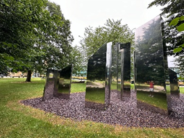 Brand new map by Simon Errington. Brand new map by Simon Errington.
1:4,000 pre-marked maps for all courses on waterproof A3 paper There is an art installation featuring multiple mirrored blocks which has been mapped as a boulder field as it was felt that the statue symbol would have misrepresented the nature of the installation (see photograph). Control descriptions are printed on the map and loose control descriptions will be provided in the start lanes. |
||||||||||||||||||||||||||||||||||||||||
| Courses | There will be 7 courses. Note that under 16s can only enter courses 6 and 7. You can run any course you like, the table below shows the course you need to run to compete in the Southern England Orienteering Urban League. If none of the classes on your chosen course fits you, enter the “Course n Open” course.
*If your dibber is not capable of holding 35 controls, you may borrow a suitable dibber free of charge by visiting enquiries on the day There will not be a string course. Senior courses run out into the local streets. Junior courses will be entirely within the university campus. There may be a small amount of slow-moving traffic within the campus including buses on the perimeter road on the way out of and back into the campus. Junior courses will not cross this road. |
||||||||||||||||||||||||||||||||||||||||
| Beginners | First timers are very welcome. Go to the event centre for help. This is an event in an urban area, which is more accessible for beginners. Dark grey blocks are buildings, which are more obvious than the variations in vegetation we use for “forest” maps. However, there are several “must not be crossed” symbols, which you need to understand. In some cases it is physically possible to cross them but not acceptable e.g. gardens, private property, hedges. |
||||||||||||||||||||||||||||||||||||||||
| Entries & Fees | Entries, via SI Entries only, close at 11.15 on the day of the event. The cost for BOF members is Adults £16, Young Adults £12, Juniors £7; for non-members, there’s a supplement of £2.
If you don’t have your own dibber (timing chip) you’ll need to hire one. SIAC (contactless) dibber hire £2. Charge for lost dibbers £65. There is no refund for cancellations less than 7 days in advance. If we have to cancel the event we will try to reschedule it. We will transfer your entry to the rescheduled event unless you ask for a refund. |
||||||||||||||||||||||||||||||||||||||||
| Starts | Starts will be in 15 minute blocks between 10:30 and 12:30
The start is 100m from the event centre, from where the route will be signed and taped. Keep to the pavement as there will be bus movements on the road Please try to start within your block so as to reduce queuing. At certain periods, notably very early, helpers will have priority. Your start time on the start list is the beginning of your start block. Courses close 14:00. Please start in good time to finish by then. |
||||||||||||||||||||||||||||||||||||||||
| Punching | SIAC will be enabled for controls on the course. The start control will be in punching mode (don’t forget to punch it), but the finish control will be in contactless mode. There will be a safety control immediately after the finish which you must punch.
Courses 1 and 2 have in excess of 30 controls so anyone on those courses with a series 5 or 8 dibber will need to collect a free loan SIAC dibber on the day at the enquiries desk in the event centre. Charge for lost SIACs £65. Otherwise, if you need to hire a SIAC (timing chip) the cost is £2.00 and this must be ordered via SIEntries as part of your entry. Charge for lost SIACs £65. |
||||||||||||||||||||||||||||||||||||||||
| Finish | The finish is located around 20m from the event centre. Follow tapes, via the safety control, to download which is located on the ground floor of the event centre. While the finish is contactless, you must punch the safety control after the finish so we can check all the runners have finished.
Water will not be provided – bring your own. |
||||||||||||||||||||||||||||||||||||||||
| Results | Live information will be available from your smartphone / tablet on www.herts-orienteering.club:
There will be WiFi available in the Event Centre via The Cloud. Full results and Routegadget will be published on www.herts-orienteering.club as soon as possible after the event. |
||||||||||||||||||||||||||||||||||||||||
| Facilities | Toilets, clothing dump, tables and chairs in Event Centre.
Sadly, the café will not be open. |
||||||||||||||||||||||||||||||||||||||||
| Dogs | Please keep dogs under control and clear up behind you. Dogs on courses would be a nuisance unless you are walking with them on a short lead. They are not allowed in the Event Centre. | ||||||||||||||||||||||||||||||||||||||||
| Safety | Orienteering is an adventure sport. You take part at your own risk and are responsible for your own safety. A full risk assessment has been carried out.
Competitors travelling alone are advised to leave something of value that they will not forget at Enquiries (e.g. car keys). All competitors are advised to carry a whistle. The senior courses involve crossing roads, take care. Junior courses stay within the campus but may encounter the occasional slow-moving vehicle. Be aware. You must report to download even if you don’t finish your course, so that we can be sure you’re back safely. First Aid will be available at the Event Centre. The nearest A&E is at the Lister Hospital, Coreys Mill Ln, Stevenage SG1 4AB. An Urgent Care Centre is available at the New QEII Hospital, Howlands, Welwyn Garden City AL7 4HQ |
||||||||||||||||||||||||||||||||||||||||
| COVID | Please do not attend if you have COVID or have recently been in contact with someone who has. A refund will be available in these circumstances by contacting the organiser.
All participants must follow the British Orienteering Code of Conduct |
||||||||||||||||||||||||||||||||||||||||
| Officials |
|

The small print
This event is registered with British Orienteering, number 84158.
Orienteering is a great sport for youngsters. If you bring children, please help us to keep to our safeguarding policy and British Orienteering’s photography policy.
Your personal data is used for results and insurance, see our privacy policy.