Burnham Ace of Herts
We hope you go to http://www.fabian4.co.uk/Default.aspx?EventID=1966 to enter our biggest event of the year, the Ace of Herts, which is a round of the South East Orienteering League. It’s not just for experts, there are courses suitable for everybody and help for newcomers.
This year we are also privileged to host the Inter-Services Championships.
Printable final details showing the information below are here. Updates since final details:
- Entry on the day is available for most courses. We have run out of Black maps and are very limited on Brown.
- Due to a transcription error on our part, some classes were assigned 1 course too high for the SE League standard: M18, M20, W16, W18, W20, W55. We apologise. The table below is now correct. Please go to Enquiries if you’d rather change your course. Note that if you run up you still get full SE League points based on your average speed, you just have to keep that average up over a slightly longer distance!
- Compass Point (orienteering equipment traders) now confirmed.
| Terrain | This is the first time that the outstanding combined area of Egypt Woods and Burnham Beeches has been used in 5 years. The shorter courses have not been into Egypt Woods since 2010. Shorter courses are wholly or mostly in Egypt Woods. This is a mixed commercial woodland on either side of a broad valley. It is mostly very runnable, though with brashings in some areas. There are relatively few paths.Longer courses additionally use Burnham Beeches, an ancient, predominantly deciduous woodland with some complex contour features on the sides of a valley. Again runnability is good apart from some areas of thick woodland which runners can avoid. |
|||||||||||||||||||||||||||||||||||||||||||||||||||||||||||||||||||||||||||||||||||||||||||
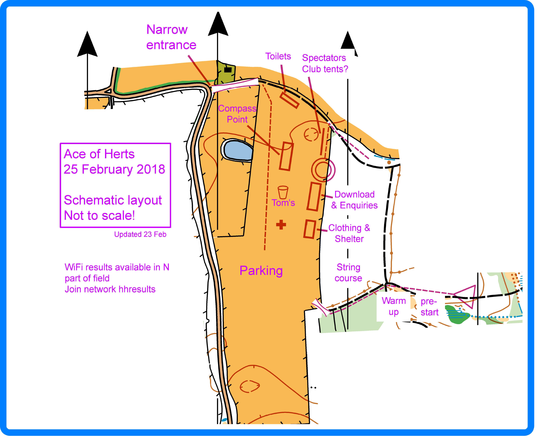
| Parking | From M40 Junction 2 (Beaconsfield) take the A355 S towards Farnham Common. Take the first exit on right, Burnham Road (6’6” width restriction), and follow O signs to Park Lane. Parking at SL1 8PL.
From the S approach on A355 and turn left on Burnham Road 500m before the M40 junction, then follow signs as above. Entry is along a narrow farm track. Please do not arrive after 1215 or leave before 1215. |
|||||||||||||||||||||||||||||||||||||||||||||||||||||||||||||||||||||||||||||||||||||||||||
| Public Transport | Burnham and Beaconsfield stations are each about 5.5km away. | |||||||||||||||||||||||||||||||||||||||||||||||||||||||||||||||||||||||||||||||||||||||||||
| Courses |
* You may enter any course, but you will only score maximum SE League points if you run the course for your own age class or above. In addition, there is a string course for the very young. |
|||||||||||||||||||||||||||||||||||||||||||||||||||||||||||||||||||||||||||||||||||||||||||
| Starts | Registration: 9.30-12.30. Starts: 10.00-12.30, call up at -4 minutes. Courses close: 14.30.Start is 250m flat walk from the east side of the car parking field (650m from the furthest point of the field). Finish is in the competition Arena.SI punching not enabled for contactless (SIAC). If a unit fails, punch your map with the backup pin punch and report it at Download.All starters must report to download, even if you do not complete the course. Start times will be allocated in advance but there will be a punching start. If you need to change your start time or course, or clarify when you can do an split start, it is best to go to Enquiries so they can give you a fresh start time, especially if you are on a busy course. |
|||||||||||||||||||||||||||||||||||||||||||||||||||||||||||||||||||||||||||||||||||||||||||
| Entry & Fees | Enter in advance via Fabian4 until 22nd February or on the day, subject to map availability.
SI card hire £1 Lost SI card fee £30 Inter-Service Championship – Men will run the Black course and Ladies the Blue and the competitive teams will be entered in the event by RAFO in accordance with Team Declarations from individual Service Team Managers. Individuals selected to represent their service will be nominated by their team manager. Other Servicemen and Women who are not selected to represent their service and wish to enter the event should do so via Fabian 4 in the same way as civilian athletes. |
|||||||||||||||||||||||||||||||||||||||||||||||||||||||||||||||||||||||||||||||||||||||||||
| Map | Updated January 2018 by Susan Marsden (Burnham) and Tom Edelsten (Egypt). Scale 1:10,000 with 5m contours redrawn to the new ISOM2017 standards by Simon Errington. Waterproof paper.
A4 for courses between White and Green (except Orange). Slightly larger for Orange and all other courses. Control descriptions are on the same side of the map as the course. Course overprinting also follows ISOM 2017 which means that control circles are a little larger (7.5mm diameter) than last year’s maps. The Black and Brown courses are each split between the 2 sides of the paper Special symbol (used on both map and control descriptions): O – log pile Loose control descriptions at start. The Yellow course has a taped route (intermittent red and white tapes) between two of its controls. For map of a previous event see here. |
|||||||||||||||||||||||||||||||||||||||||||||||||||||||||||||||||||||||||||||||||||||||||||
| Facilities | Toilets, Tom’s catering van, Compass Point, string course nearby, tent for clothing etc.
|
|||||||||||||||||||||||||||||||||||||||||||||||||||||||||||||||||||||||||||||||||||||||||||
| Dogs | Dogs permitted in the car park on a lead. Please tidy up after your dog. | |||||||||||||||||||||||||||||||||||||||||||||||||||||||||||||||||||||||||||||||||||||||||||
| Safety | Orienteering is an adventure sport. You take part at your own risk and are responsible for your own safety.
Swallow holes appear as very large wet depressions, usually fairly overgrown. Anybody entering them is at risk of drowning. They are marked as Out of Bounds on the map, but the best advice is: DO NOT ENTER ANY FEATURE LOOKING LIKE THIS UNLESS YOU KNOW THERE IS A CONTROL THERE. Even if your course goes near one (White and Yellow do not), the best route is always to the side of it. In the event of bad weather cagoules may be compulsory – signs will be exhibited on the route to the start before you leave the arena. Whistles are advised for all competitors. An emergency number is printed on the map (Organiser) |
|||||||||||||||||||||||||||||||||||||||||||||||||||||||||||||||||||||||||||||||||||||||||||
| Out of bounds | Out of bounds areas are denoted by olive green or by magenta cross hatching. Do not cross them irrespective of whether the line between controls passes over them. The courses have been planned so there is no advantage in crossing any of these areas. They include:
Additionally, one section of road is out of bounds and marked with magenta crosses. There is a 3 wire barbed wire fence running east-west along the boundary between Egypt Woods and Burnham Beeches. It can be climbed by any but the least agile, but 6 non-mandatory crossing points have been marked on the map. Two are existing footpath crossings to which some red and white tape has been added. Four are simple temporary crossings where the barbed wire has been protected with foam pipe insulation. These are also marked with red and white tape. |
|||||||||||||||||||||||||||||||||||||||||||||||||||||||||||||||||||||||||||||||||||||||||||
| Results | Times taken between each control and your total time for the course will be printed for you at download.
Intermediate results, updated every few minutes, will be available by joining the wifi network hhresults. You don’t need a mobile phone signal (or even a SIM if you’re using a tablet) because it’s a local wifi network. Results will be posted on paper intermittently during the day, rather less frequently than wifi results are updated! Full results will be published on www.herts-orienteering.club and Routegadget as soon as possible after the event. |
|||||||||||||||||||||||||||||||||||||||||||||||||||||||||||||||||||||||||||||||||||||||||||
| Officials |
|