Ashridge Compass Sport Cup Heat
The final details below are also available in pdf form for download and printing. The pdf will not be updated, but this page may – for instance if the weather is bad – with updates clearly marked.
The SE heat of the Compass Sport Cup and Trophy, the premier UK inter-club competition, will be held at Ashridge, using the eastern and southern part of the area. There is almost no overlap with the map for 2016’s event in Ashridge North. Longer courses will visit Northchurch Common, which has been remapped for the event, having been out of use for many years.
We welcome the following clubs:
- Compass Sport Cup: SLOW, SO, WAOC, HH
- Compass Sport Trophy: CHIG, DFOK, HAVOC, LOK, MV, SAX, SMOC, SOS, SUFFOC
| Summary |
|
||||||||||||||||||||||||||||||||||||||||||||||||
| Terrain | Ashridge is a fine area of runnable, mostly deciduous woodland with many open glades on a chalk downland plateau. The newly mapped area is mostly on the dip slope and is a mosaic of woods of varying degrees of runnability, rough open land and gorse thickets.
The forest is in great shape for fast running. Storm Doris brought a few more trees down, which have been tidied up. The bracken and brambles have died back well this winter so should not significantly affect running speeds except where mapped. A planning aim is that the winners of the technical courses will have done little path running. The beginners’ courses inevitably use paths, and these can be very muddy: participants should ensure they have appropriate footwear. We would like to thank the National Trust, and Ashridge Estate in particular, for access to this excellent forest. |
||||||||||||||||||||||||||||||||||||||||||||||||
| Parking | 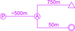 At Ashridge Executive Education Hult. Signed from junction with Nettleden Road in Little Gaddesden, SP992134, nearest postcode HP4 1NU. From there 1.4km on road with speed ramps to hard standing parking. Parking to event centre ~500m mostly on mown grass. At Ashridge Executive Education Hult. Signed from junction with Nettleden Road in Little Gaddesden, SP992134, nearest postcode HP4 1NU. From there 1.4km on road with speed ramps to hard standing parking. Parking to event centre ~500m mostly on mown grass.100m of the entrance is single track and round a blind bend, so please arrive before 12:00 and exit after 12:00 only. If you absolutely must travel outside those times you must give priority to incoming / outgoing traffic.Parking fee £1 per vehicle to go to the Restoration Fund. Many thanks to Ashridge Executive Education for allowing us use of their car parks.Please leave the event the way you came in, to the North via Little Gaddesden. |
||||||||||||||||||||||||||||||||||||||||||||||||
| Route to Event Field | Only exit the car park via the pedestrian gate. Do not use the vehicle entrance.
Follow tapes along the front of the management college and then take care at unmanned minor road crossing. |
||||||||||||||||||||||||||||||||||||||||||||||||
| Public Transport | Trains to Tring station, 5.1km walk via Aldbury and Bridgewater Monument. The route from Berkhamsted station is slightly longer and passes through the competition area, so do not use it.
There are no buses on Sundays. Taxi from Tring or Berkhamsted stations is an option. |
||||||||||||||||||||||||||||||||||||||||||||||||
| Entry on the Day (EOD) | You can enter, Light Green, Yellow, and White on the day, but not the age defined Compass Sport and Trophy courses. £12 seniors / family groups, £5 juniors / pairs |
||||||||||||||||||||||||||||||||||||||||||||||||
| Event layout | 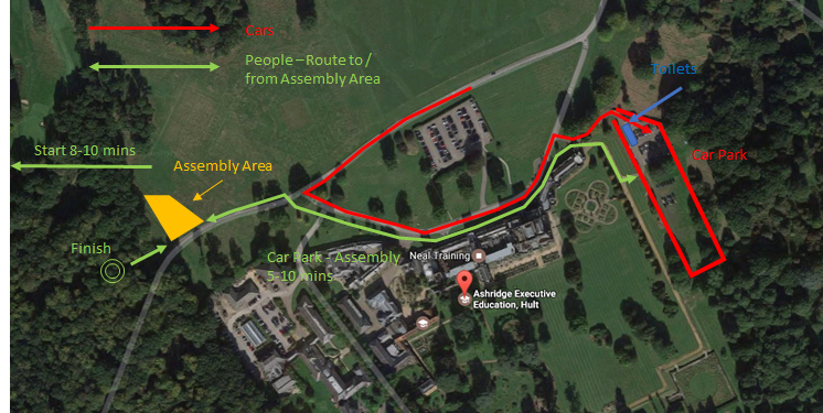 |
||||||||||||||||||||||||||||||||||||||||||||||||
| Toilets | Will be available in the car park. There are none at the start or assembly area. | ||||||||||||||||||||||||||||||||||||||||||||||||
| Assembly area | Registration, Download, Club Tents and First Aid are all located very near the finish 5-10 minutes’ walk from the car park. We are afraid we don’t have any traders or refreshments. Spectators are welcome alongside the run in to the finish. |
||||||||||||||||||||||||||||||||||||||||||||||||
| Start | There is one start for all courses 8-10 minutes’ walk (750m) from the assembly area and 13-20 minutes’ walk from the car park. Follow the taped route.There is plenty of room to warm up E of pre-start and S of the main forest track that forms part of the taped route. |
||||||||||||||||||||||||||||||||||||||||||||||||
| Start times | Except for colour coded, all start times are pre-allocated to clubs and are being distributed via club captains. There are fixed slots for each club, so if you are going to miss your start you must change your start time at registration. You won’t be able to arrive at the start and hope for a late start as this will not be possible. Some courses e.g. Green are full at points in the day, so you could potentially be waiting an hour in the cold, so please be safe and change your time and then wait in the car / club tent. It is also after all a competition and not having spaced out club runners because of late starts would be unfair – you have been told :-). Call up is at -4 minutes. Loose control descriptions are available in the start lane. |
||||||||||||||||||||||||||||||||||||||||||||||||
| Courses | Compass Sport Cup courses from Orange to Brown, plus White, Yellow and Light Green. Course lengths and the relevant Compass Sport Cup / Trophy classes are:
|
||||||||||||||||||||||||||||||||||||||||||||||||
| Starts | 1000-1239 (sic)
There is one start, 750m level walk from the event centre. Follow the taped route. There is plenty of room to warm up E of pre-start and S of the main forest track that forms part of the taped route. Call up will be at -4 minutes. If you miss your start time you will only be allowed to start in one of the start slots on that course allocated to your club. That may mean a significant wait (but your club captain should be able to give you an idea). As it is a punching start you will get a valid time. |
||||||||||||||||||||||||||||||||||||||||||||||||
| Punching | Sportident punching will be used. Dibber hire £1. Charge for lost dibbers £30. |
||||||||||||||||||||||||||||||||||||||||||||||||
| Map | 1:10000 with 5m contours, courses premarked on waterproof paper. Green and shorter courses use maps that are about 2cm wider than A4 landscape. Maps for courses 1-4 are the same width but about 1.5x the height i.e. a little wider but rather shorter than A3 portrait.
For map of a previous event see http://www.happyherts.routegadget.co.uk/rg2/#149. The map for this event covers the southern part of that map, with a significant extension to the south newly mapped by Susan Marsden. |
||||||||||||||||||||||||||||||||||||||||||||||||
| Finish | The finish is on a track about 50m from download in the assembly area. You must report to download. Lone competitors to leave a car key with registration / download. There is no water at the finish, so please bring your own. |
||||||||||||||||||||||||||||||||||||||||||||||||
| Results | Results will be available via WiFi in the assembly area and we will also be posting them physically on boards nearby.
For wifi results, join the network “hhresults”. No password is needed. You should land on the main results page. You may need to be within ~50m of the download tent to get a decent signal. |
||||||||||||||||||||||||||||||||||||||||||||||||
| Pre- and post- event refreshments | The National Trust runs the excellent Brownlow Café near Ashridge Monument, which is a short drive or just over 2km walk away.
Please don’t leave your car in the event car park though beyond 2:30, as that would lead us to think you are missing injured in the forest and not having an NT cup of tea :-). |
||||||||||||||||||||||||||||||||||||||||||||||||
| Safety | Orienteering is an adventure sport. You take part at your own risk and are responsible for your own safety.
There is a 2-minute timed crossing point across the main B4506 road through the area on the Blue and Brown courses. This will be used in both directions, and the time between the two controls on either side will be deducted from your overall time, so after crossing safely please don’t dawdle. Please take care crossing all roads, and follow marshals’ instructions. Running along the B4506 itself is out of bounds. There is then another more minor road crossing on both Brown and Blue courses. Both Green courses cross and re-cross a minor access road to the College, with little traffic. Take care even though vehicles are slowed down by speed ramps. If you are injured and finish, please use the first aid in the assembly area. If you see another badly injured competitor, then please help them and then if necessary enrol another competitor to get help from the event team. |
||||||||||||||||||||||||||||||||||||||||||||||||
| Weather & Safety | If it is pleasant spring day, then whistles will be advisory, but no other precautions will be necessary.
However, in the event of winter weather we reserve the right to make whistles mandatory and to enforce a no cagoule no go policy. |
||||||||||||||||||||||||||||||||||||||||||||||||
| Out of Bounds Areas | There are various fields that are out of bounds, and one ancient monument that is also out of bounds. All are marked on the map. Please avoid these areas. | ||||||||||||||||||||||||||||||||||||||||||||||||
| Other Users of the Wood, and Deer | Please can you be considerate to other users of the wood; walkers, dog walkers and horse riders. Then please note that there are lots of deer, albeit they generally don’t come too close to runners. | ||||||||||||||||||||||||||||||||||||||||||||||||
| Protests / Complaints | If you have a comment or complaint please discuss it with the Planner, Organiser or Controller before putting it in writing.
If you wish to register an official protest, please do so in writing at the download and registration tent. We then have a jury who will adjudicate. |
||||||||||||||||||||||||||||||||||||||||||||||||
| Last minute changes | In the event of severe weather before the event, this page will be updated and a notice put on the home page of this website. | ||||||||||||||||||||||||||||||||||||||||||||||||
| Officials |
|