Ashridge N Ace of Herts
Updated Friday Feb 23rd: Parking arrangements have changed. Please see below. Allow a little more time to reach the Start and share transport if at all possible.
We welcome you to our biggest event of the year, the Ace of Herts, a National event which is a round of the South East Orienteering League. It’s not just for experts, there are courses suitable for everybody and help for newcomers.
These details can be printed – to paper or PDF – using the blue ‘Print this page’ button at the bottom.
| Location | The event centre and parking field is on the W side of the B4506 at Ringshall HP4 1NR. | |||||||||||||||||||||||||||||||||||||||||||||||||||||||||||||||||
| Terrain | Ashridge North is a fine area of gently undulating deciduous woodland with a scarp slope to the west with areas of contour and vegetation detail.
The going is generally very fast with some limited areas of denser woodland. Since our last event here, many of the areas of rhododendron have been cleared but there are increasing areas of brambles. The larger paths can be muddy, making straight routes through the forest more attractive. The National Trust have asked that if you do run along paths, you follow the main line even if it is wet or muddy; running round the edges damages the vegetation much more. Notices asking the public to stay on the paths because of deer management activity can be ignored and there will no such activity on the day of the event. The area is much used by walkers (many with dogs and/or buggies) and horse riders. Please be considerate to them to help ensure our continued access to this area. We would like to thank the National Trust, and Ashridge Estate in particular, for access to this excellent forest. |
|||||||||||||||||||||||||||||||||||||||||||||||||||||||||||||||||
| Parking | 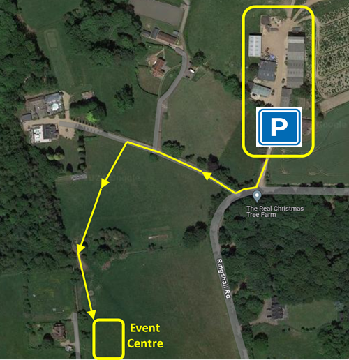
The rainfall over recent weeks has forced us to move as much parking as we can to hard-standing at the Real Christmas Tree Farm which is 400m N of the previously advertised location. Once the farmyard is full, we will revert to the original field for the overflow. Please follow the Orienteering signs on the B4506 to ensure you get to the correct car park. The farm drive entrance is at the bend on the B4506, what3words valve.tiny.loafing. It is 500m off-road from the P in the diagram to the event centre via the route shown. Allow yourself extra time to get to your start please. Our thanks to the farm for helping us out. Please note they have no liability for any damaged incurred while on their property. And strictly No Smoking as there are flammable materials around. The entrance to the main event field is on the B4056 at Ringshall, just N of the junction with the road from L Gaddesden, what3words paper.mocking.flotation. Take care on approach. There is no parking charge. There is no car access from anywhere on Beacon Road. |
|||||||||||||||||||||||||||||||||||||||||||||||||||||||||||||||||
| Public Transport | Limited! | |||||||||||||||||||||||||||||||||||||||||||||||||||||||||||||||||
| Beginners | First timers are very welcome. Look for our greeters in hi-vis jackets who will help you.
If you’ve not orienteered before, we suggest most people start with the yellow course. Young juniors, say primary school age, and family groups with young children are better on white. People confident with a map and compass may start on orange. It’s better to start simpler. If you find a course too easy, our policy is to allow you to run the next course up for free, if there’s time and there are maps available. Don’t forget to download between runs! |
|||||||||||||||||||||||||||||||||||||||||||||||||||||||||||||||||
| Courses | Provisional course lengths below. Quoted course lengths are straight line distances, you will run further. There also will be a String Course set up close to the the Start.
The age classes are those recommended for the South East League (2023). You may run any course you wish*, but please take note of the course closure time if you are running a longer course than usual. *Under 16s may run courses up to Blue but no longer, due to road crossing. |
|||||||||||||||||||||||||||||||||||||||||||||||||||||||||||||||||
| Course Notes | The weather leading up to the event has not been kind to us. Many paths are squelchy and some pits and depressions have standing water. There are also many fallen trees in the area including some across paths that may affect all courses. Please tell juniors that if they see a tree down it doesn’t (necessarily) mean they’ve gone the wrong way, there is a way through.
Keep clear of out of bounds areas marked on the map. Courses have been planned so that you will not gain by going through them. They are there for environmental or archaeological reasons and some are marked with only occasional signs. A previous planner on this area said “if you’re not near the purple line, why not?” The increasing bramble has changed that somewhat, but the patches are accurately mapped and give a good indication of the runnability of an area. As with all vegetation, the edges are sometimes indistinct so cannot be relied upon for fine navigation. |
|||||||||||||||||||||||||||||||||||||||||||||||||||||||||||||||||
| Maps and control descriptions | Maps are pre-printed on waterproof paper, scale 1:10,000 with a 5m contour interval for all courses. Courses up to Short Blue are A4 size, Blue and above A3. The Black map is double sided. White and yellow course maps are available at the pre-start.
The map has been completely resurveyed and redrawn for this event by Simon Errington, using LiDAR data:
Loose control descriptions, pre-printed on waterproof paper, will be in the start lanes. Descriptions will also be printed on maps. |
|||||||||||||||||||||||||||||||||||||||||||||||||||||||||||||||||
| Starts | You may choose a start time between 10.00-12.30. Please make every effort to get there for your start time although late starts will be available. Call up is at -4 minutes.
The start is c.300m from the parking field. The route is along a public footpath which is also used for vehicle traffic to 3 cottages. You are unlikely to see any vehicles but be aware. Leave by the W exit besides download and follow signs and tapes. The route to the start and back from the finish crosses a minor road; the crossing will be marshalled. There is limited room at the pre-start on the south side of the road. Please warm up before the road crossing; we reserve the right to hold people at the road crossing until 5 minutes before their start if it gets too busy. Courses close promptly at 14.00. Please choose a start time that will give you ample time to complete your run by then. |
|||||||||||||||||||||||||||||||||||||||||||||||||||||||||||||||||
| Entry & Fees | Entries are now open. All entries are made online through SI Entries. You can enter up to 11:00 on the day (subject to map availability).
If you don’t have your own dibber (timing chip) you’ll need to hire one. SIAC (contactless) dibber hire £2. Charge for lost dibbers £65. If in a group, you may order extra maps at £1 each. |
|||||||||||||||||||||||||||||||||||||||||||||||||||||||||||||||||
| Punching | SIAC will be enabled. It will be a punching start. Finish is contactless, everybody must punch the safety control immediately after the finish. | |||||||||||||||||||||||||||||||||||||||||||||||||||||||||||||||||
| Facilities | 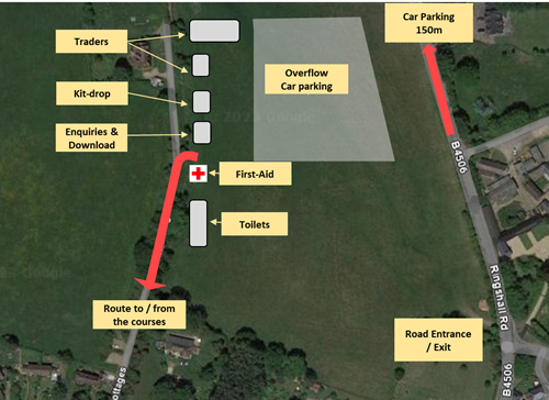 Parking Parking
Enquiries / SIAC collection Download First-Aid by White Star Medical Porta-loos Kit / key drop Tom’s Burger Van Compass Point kit suppliers |
|||||||||||||||||||||||||||||||||||||||||||||||||||||||||||||||||
| Results | Live results will be posted every few minutes to https://www.herts-orienteering.club. Full results will be published on the same page and on Routegadget as soon as possible after the event. We aim to put provisional results up that evening. |
|||||||||||||||||||||||||||||||||||||||||||||||||||||||||||||||||
| Event cancellation | Extreme weather conditions could result in late cancellation of the event. If cancellation is needed a message will be posted on the www.herts-orienteering.club website and an email sent to all those entered as soon as is possible after a decision has been made.
Please check before travelling. |
|||||||||||||||||||||||||||||||||||||||||||||||||||||||||||||||||
| Dogs | Dogs are allowed under control in the parking field but may not accompany competitors on courses due to the presence of deer all over the forest. | |||||||||||||||||||||||||||||||||||||||||||||||||||||||||||||||||
| Safety | Orienteering is an adventure sport. You take part at your own risk and are responsible for your own safety. A full risk assessment has been carried out.
Roads around the perimeter of the map, are out of bounds including their verges. The B4506 has a 50mph speed limit. Black, Brown and Short Brown courses cross Monument Drive, the main access road for visitors to Ashridge. Traffic is generally slow moving but take care. You are advised to carry a whistle. In the event of extreme weather on the day, cagoules may be compulsory. Large numbers of deer live in Ashridge; please allow them to move away from you without chasing and panicking them. If ever a deer does not move away from you then it is injured and should not be approached. Ponds and marshy areas may be deeper and muddier than you think. Paths can also be muddy. The area is popular with cyclists, dog walkers and horse riders. Please show them due consideration. First Aid will be available at the car park 200m from the finish. The nearest hospital is the Luton and Dunstable Hospital Trust, Lewsey Road, Luton LU4 0DZ, 9 miles from the event. You must go to Download even if you don’t finish your course. We need to confirm you’re back safely. |
|||||||||||||||||||||||||||||||||||||||||||||||||||||||||||||||||
| Officials |
|
The small print
This event is registered with British Orienteering, number 81143.
Orienteering is a great sport for youngsters. If you bring children, please help us to keep to our safeguarding policy and British Orienteering’s photography policy.
Your personal data is used for results and insurance, see our privacy policy.