Ace of Herts 2026 Egypt Woods
5 Feb: These are now final details. You can print them to a printer or PDF with the blue Print this Page button.
Any changes from now on will be marked up in red and summarised here. If the change is critical we will email you.
Feb 07: Google maps comment added
Event Summary
|
Welcome
We welcome you to what is normally our biggest event of the year, the Ace of Herts, a National Middle distance event which is a round of the UK Orienteering League and the South East Orienteering League. It’s not just for experts, there are courses suitable for everybody and help for newcomers.
This year the event is part of the British Night Championships weekend, the morning after the Night event.
We are also proud to host the Inter-Services Championships.
Location
Egypt Woods, near Beaconsfield Buckinghamshire.
Parking
Harehatch Lane, Egypt, nearest postcode SL1 8PQ, OS Grid reference SU948872, What3words care.punks.cone. You must approach from the A355 2km S of M40 J2, turn W at ///luck.wages.scan. Other routes involve narrow lanes, some with width restrictions, so using them would cause congestion.
Public Transport
Burnham and Beaconsfield stations are each about 5.5km away. Bus 103 passes the end of Harehatch Lane.
Beginners
First timers are very welcome. Look for our greeters in hi-vis jackets.
You can go around individually, in pairs or in a larger family group. From an entries perspective, pairs and groups are treated as a single runner – it’s one entry, you get one map, one timing chip (“dibber”) and one finish time listed in the Results. We charge per “entry” not per person and it’s easiest to enter in advance – see Entering for the first time for more info on how to do this.
If you’ve not orienteered before, we suggest most people start with the yellow course. Young juniors, say primary school age, and family groups are better on white. People confident with a map and compass may start on orange. If you find your course too easy, club policy is to offer you a run on the next course up at no cost, provided there’s enough time and there are maps available.
Don’t forget to download between runs!
Terrain
Egypt Woods is a mixed commercial woodland on either side of a broad valley. It is mostly very runnable, though with bracken and brashings in some areas. There are relatively few paths. Hangings Wood and Jennings Wood have similar terrain but with much less plateau running.
Map
1:10000 (1:7500 for courses primarily for 65+ competitors) pre-marked maps for all courses on waterproof paper. For a previous event see Routegadget.
Area remapped in Feb-Mar 2025 using LiDAR data, with revisions in winter 2025/26, by Simon Errington.
Loose control descriptions available in the start lanes.
Course Timing
Sportident punching will be used. SIAC will be enabled for those with ‘contactless’ dibbers, but you must punch start. Finish is ‘fly by’.
Facilities
- CompassPoint for equipment
- Tom’s burger wagon for food
- Marquee for socialising
- Toilets
- First aid provided by White Star Medical. If you wish to declare a medical condition or other vulnerability you may leave a note at Enquiries (in the marquee) in a sealed envelope with your name on the outside and retrieve it afterwards. The envelope will not be opened unless you trigger our Missing Runner Procedure or Casualty Procedure.
There is also a string course for the very young, just after the road crossing on the way to the start. No charge, just turn up.
Photos will be taken by David Dixon. If you do not wish your photo to be taken, in accordance with the British Orienteering Policy you may fill in a Right to Object form and leave it at enquiries.
Dogs
Sorry but no dogs allowed in either the car park or Egypt Woods.
Safety
By participating in this event, you acknowledge that you do so at your own risk and are responsible for your own safety.
A full risk assessment has been carried out.
There is a 2 minute timed out road crossing for all courses except White, Yellow, Orange and Very Short Green. Those 4 courses cross the road on the way back from the Finish. Both crossings will be marshalled but take care crossing the road.
One steep slope will be taped off at the top with yellow and black tape and marked on the map.
On courses you will meet the usual slip and trip hazards. Shoes with good grip are recommended. Water features are in general shallow and courses are planned to avoid the worst.
The safety bearing is N before the road crossing, S after the road crossing.
Cancellation
If we have to cancel the event, a notice will be placed at the top of this page and all entrants notified by email and/or text. Please check before travelling, especially if weather warnings are issued.
Officials
| Planners | Helen Marsden & Alan Rosen |
| Organisers | Mike Bennett & Alan Rosen |
| Controller | Neil Crickmore (SO) |
The small print
This event is registered with British Orienteering, number 85815.
Members of British Orienteering—which includes those who have joined an affiliated club such as HH—are covered by the organisation’s public liability insurance. Please note: If you are not a BOF member, if you accidentally injure someone or damage property during the event, you are not covered by this insurance.
Orienteering is a great sport for youngsters. If you bring children, please help us to keep to our safeguarding policy and British Orienteering’s photography policy.
Your personal data is used for results and insurance, see our privacy policy.
Courses
Courses for everybody from beginners of any age to experienced orienteers. The courses are Middle distance so shorter than usual. We use the course/class combinations from the SE Middle Championships, which are slightly different from the usual UK Orienteering League and SE League courses. If you wish your results to count for UKOL you must enter the course for your class. For SE League you get full points if you run your age class course or longer, reduced points if you run shorter.
| Course | Men | Women | Scale (k) | Distance (km) | Climb (m) |
| Black | M18, M20, M21, M35, M40 | 1:10 | 6.9 | 115 | |
| Brown | M16, M45, M50 | W18, W20, W21, W35 | 1:10 | 5.4 | 100 |
| Blue | M55, M60 | W40, W45, W50 | 1:10 | 4.9 | 75 |
| Green (Women) | W16, W55, W60 | 1:10 | 4.3 | 60 | |
| Green (Men) | M65, M70 | 1:7.5 | 4.3 | 60 | |
| Short Green | M75 | W65, W70 | 1:7.5 | 3.6 | 45 |
| V Short Green | M80, M85 | W75, W80, W85 | 1:7.5 | 2.5 | 30 |
| Light Green | M14 | W14 | 1:10 | 3.2 | 50 |
| Orange | M12 | W12 | 1:10 | 2.1 | 30 |
| Yellow | M10 | W10 | 1:10 | 2 | 25 |
| White | 1:10 | 1.6 | 10 |
If you are on the Green course, please ensure you pick up the correct scale map.
Course Notes
Egypt Woods is a mixed commercial woodland; there are large areas of very runnable beech, oak and pine forest as well as areas of recent forestry work and a number of fenced-off pheasant pens. The later part of the longer courses visit the woods North of Harehatch Lane, which contains steeper-sided re-entrants than the rest of the area.
Green areas to the south of Harehatch Lane are mainly holly and those to the north are mainly rhododendrons and patches of windblown trees. There are areas of dead bracken across the whole map but in most places this is intermittent and has died back enough to have little impact on running speed. The most significant bracken is in the central third of the map. Where this reduces running speed in what would otherwise be white forest or open areas, widely spaced green stripes are used. The map reflects the situation in the middle of January and any subsequent frost, rain and snow will only improve runnability. The area is surprisingly free of brambles. Where they do occur in the south of the map they are shown using closely spaced green stripes. Courses are planned to avoid them.
In the south west of the map there is a block of forest that was thinned about a year ago and which has been left with extensive brashings on the ground. These are mapped, as for bracken, using widely spaced green stripes. Piles of brashings can also be found at the edge of major tracks.
Rootstocks are only mapped if more than about 2m high. Some still have their tree attached. Earth features such as earthwalls, dry ditches and knolls tend to be small.
Minor paths are not always easy to follow, especially where covered with fallen leaves or affected by bracken, and are mapped as intermittent. Much of the area is relatively dry, although seasonal streams and marshes are currently very wet.
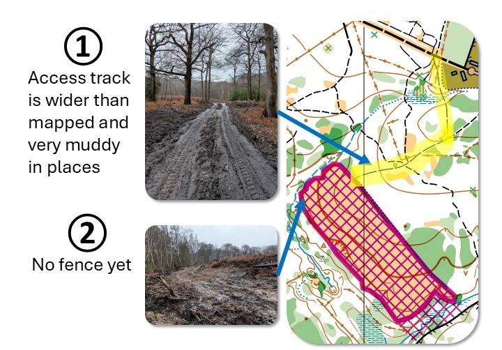 In the south of the map there is a large (400m x 100m) clear-felled area which, by the time of the event, may or may not have a deer fence around it. It didn’t on 1 Feb. Either way, it is marked as out of bounds on the map with a notional fence round the perimeter. The whole open area is out of bounds.
There may be some stakes out still out in the forest from BNOC the night before, but they will not have flags or boxes.
Start and Finishes
When you enter, you can choose a start time between 10:30 and 12:30. Please do your best to arrive in time for your start. There are very few gaps on the longer courses to slot late starters into.
Courses close 14:30. Please choose a start time to allow yourself plenty of time to finish before then.
The start is 700m from the event centre, allow 15 minutes plus 4 minutes for call up. Note the start is slightly farther than the start for the British Night Championships the night before.
There are two finishes. For all courses except White, Yellow, Orange and Very Short Green, the finish is adjacent to the event centre. For White, Yellow, Orange and Very Short Green, the finish is South of Harehatch Lane, close to the start, so will involve a short walk (~700m) back to download. That route involves the same manned crossing as you used to get to the start. There will be an unsupervised clothing dump near the start and the finish for the shorter courses.
Entry & Fees
Entries now open at SI Entries.
| Up to Feb 1 2026 | From Feb 2 2026 | |||
| BOF members | non-members | BOF members | non-members | |
| Seniors | £16 | £18 | £18 | £20 |
| Young Adults | £11 | £13 | £13 | £15 |
| Juniors and full time students | £6 | £8 | £8 | £10 |
Entrants to the Inter Services Championships should already have entered through their club.
If you don’t have your own dibber (SI or SIAC) you’ll need one. SI cards £1, SIAC £2.
If you want an extra map so that each member of your group has one (recommended!), they are £1 each.
You can enter online up to 12:00 on the day while maps are available, but if you need SI or SIAC hire please enter by Friday 30th 23:59.
Results
Interim results will be published direct to the club website every few minutes during the event. There will be a QR code on your splits printout. There will be no printed results (apart from your own splits) or WiFi available.
Full results will be published to the same location and to Routegadget; we aim to do so on the day of the event.
Complaints
If you have any issues regarding the competition or results they should be raised with the Organiser. Section 13 of the Rules of Foot Orienteering will be followed. A Jury will be appointed to deal with any protests.